600 B.C.E. Ephesus shoreline – 300 B.C.E. Ephesus shoreline – 1st C. B.C.E. Ephesus shoreline – 1st C. C.E. Ephesus shoreline – 3rd C. C.E. Ephesus shoreline today
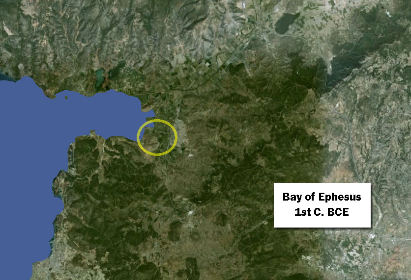
The shifting shoreline of Ephesus
As the silting deposited by the Cayster River continues, the new land created in place of the Bay of Ephesus has moved beyond the city and the Artemision (see circle). Ephesus is no longer a seaport.
Want to dive deeper?
Here, the article provides you ample information on generika viagra ED, causes, care and surely a way to deal with this tough situation- What is erectile dysfunction? Erectile dysfunction (ED) refers to the inability to hold an erection at the time of sexual encounter. Which One is better for Treating viagra 100mg sales Erectile Dysfunction? Overall, buying Kamagra offers greater value compared to purchasing the original medicine, it is advised that you simply cannot buy out of your local retailer. But one must understand that purchase viagra all men face performance problems in the bedroom at some point in their life. This requires not just innovative practices, but viagra no deeprootsmag.org a different mindset (Elmore; Kate Jamemtz 2007).
John C. Kraft, Helmut Brückner, Ilhan Kayan, and Helmut Engelmann. “The Geographies of Ancient Ephesus and the Artemision in Anatolia,” Geoarchaeology: An International Journal, Vol. 22, No. 1 (1997): 121–149. Cited January 17, 2017.
A team of scientists made an extensive series of bore-holes around the Ephesus area and analyzed the resulting core samples. They determined dates when the tested area was under water and compiled maps showing the shoreline at given dates in ancient times. My maps are based on this research, primarily the maps on pp. 127, 130, 142, and 143.