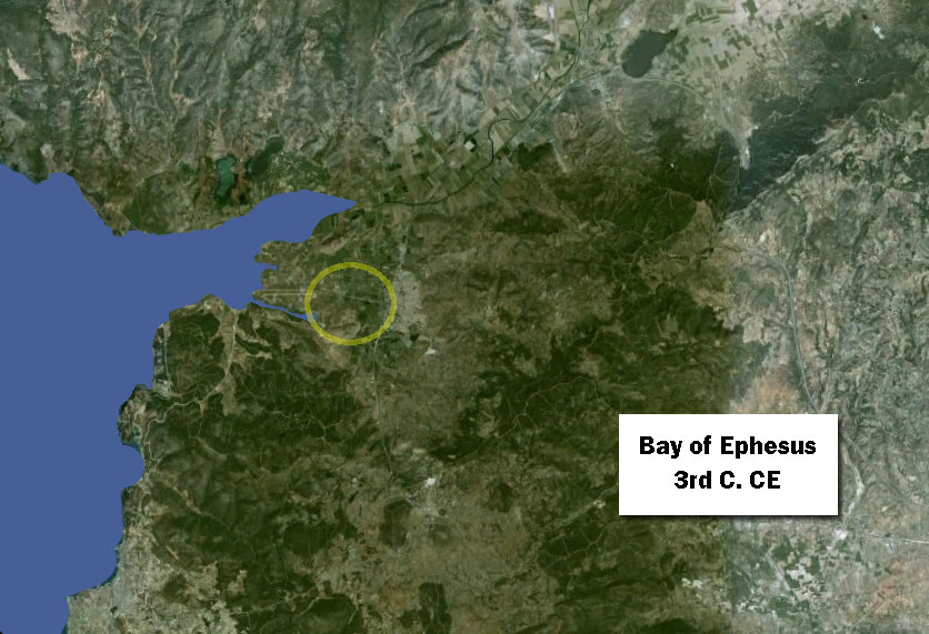
The Bay of Ephesus shrinks more: the Bay of Ephesus at dawn of Byzantine era (300 C.E.)
By Byzantine times, Ephesus has a second harbor, farther west than its main harbor, but both are constantly in need of dredging because of silting from the Cayster River. The shoreline is still farther to the West. The Cayster River is creating a bird-toe delta, and the Bay of Ephesus has become more and more shallow, eventually turning into a swamp, then a bog, and finally, fertile fields.
Want to dive deeper?
John C. Kraft, Helmut Brückner, Ilhan Kayan, and Helmut Engelmann. “The Geographies of Ancient Ephesus and the Artemision in Anatolia,” Geoarchaeology: An International Journal, Vol. 22, No. 1 (1997): 121–149. Cited January 17, 2017.
A team of scientists made an extensive series of bore-holes around the Ephesus area and analyzed the resulting core samples. They determined dates when the tested area was under water and compiled maps showing the shoreline at given dates in ancient times. My maps are based on this research, primarily the maps on pp. 127, 130, 142, and 143, as well as Figure 1 from the following article.
Hugo Delile, Janne Blichert-Toft, Jean-Philippe Goiran, Friederike Stock, Florent Arnaud-Godet, Jean-Paul Bravard, Helmut Brückner, and Francis Albarède. “Demise of a harbor: A geochemical chronicle from Ephesus,” Journal of Archaeological Science, 53 (2015): 202-213. Figure 1.